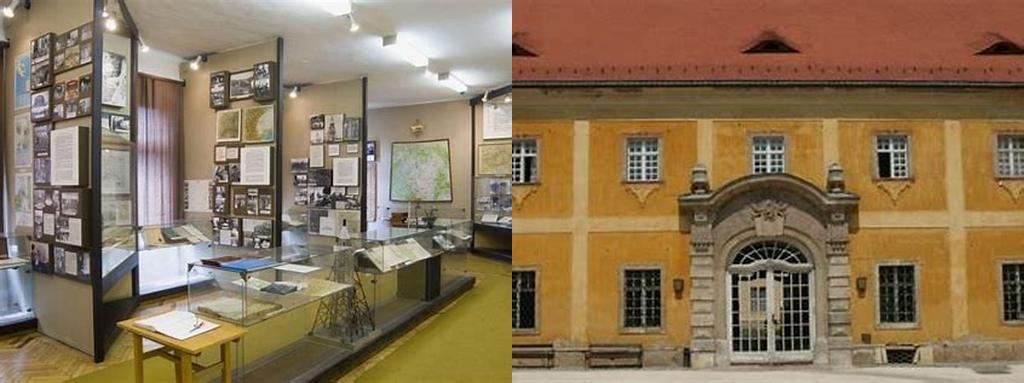
If you’ve ever peered at a map and wondered just how much history and mystery those lines contain, find your way to the Magyar Katonai Térképészet Szakmatörténeti Múzeuma, hidden in the leafy Buda Hills on the outskirts of Budapest. This unique museum is dedicated to the professional story of Hungarian military cartography—a discipline that’s more dramatic and ingenious than it sounds. The museum may be a little off the beaten tourist path, but that’s a big part of the appeal. Inside, you step into a world where science, artistry, and history collide, revealing centuries of secrets once inked onto parchment in candle-lit war-rooms.
Hungarian military mapping has deeper roots than you might guess. By the late 18th century, cartographic teams trekked across the Carpathian Basin, surveying land for the Habsburg Empire, their theodolites and notebooks in tow. The museum’s collection brings out the real, tangible drama of their trade: you can peer at ancient theodolites, meticulously hand-drawn sketches, and elaborate colored maps that once determined the fate of cities and armies. The first great military mapping survey, the First Military Survey of the Habsburg Empire (1763–1787), gets ample attention here. Walk slowly through the halls and you’ll see expertly displayed documents that look less like old military paperwork and more like works of art, startlingly detailed even centuries later.
Among the many faces of Hungarian cartography, the name Lajos Loczy stands out—a leading geographer and geologist who, in the late 19th and early 20th centuries, helped pioneer the careful mapping of rivers, mountains, and borders during a time of shifting world powers. The museum doesn’t just showcase the artifacts and maps themselves; it delves into the people behind them, introducing visitors to scientists, officers, and even codebreakers who used these maps to plan campaigns and avoid disasters. If you’re a fan of intellectual detective work, you’ll be drawn to stories of how Hungarian cartographers outfoxed would-be invaders through clever map design and data hiding.
World War I and II take up whole rooms, where you can trace the evolution from hand-drawn to photogrammetric and aerial maps. There’s something rewarding about seeing the actual instruments—planimeters, photo-interpreting tools, early aerial cameras—that once changed hands in high-ceilinged, echoing map rooms. Exhibits detail the top-secret work of military cartographers whose maps not only depicted reality but also shaped it, guiding troops and altering the outcome of battles. Period photos, battered leather-bound field books, and intricate relief maps bring to life just how much was at stake every time a new border was drawn or a hill measured.
Of course, the museum isn’t just about the distant past. It explores the uneasy dawn of the digital age in military mapping. Computers, satellites, and Geographic Information Systems (GIS) changed everything, and the exhibits trace Hungary’s response to a rapidly modernizing—and digitizing—world. You can track the shift from painstaking handwork to early computer-aided cartography, and marvel at the persistence of intuition and human skill, even as algorithms replaced some of the old artistry.
The building itself deserves a mention, having witnessed decades of whispered conversations and strategic planning. Nestled amid pine trees, it offers glimpses of Gellért Hill through the windows, quietly connecting you to the landscapes mapped so diligently over the centuries. Whether you’re a history buff, a map lover, or simply someone who appreciates unsung stories, the Magyar Katonai Térképészet Szakmatörténeti Múzeuma rewards curiosity with endless layers of intrigue. Every gallery leaves you with the sense that the world, when carefully mapped, becomes not just knowable, but fascinating, fraught, and always—if you’re lucky—just a little mysterious.